Habikino
Habikino
羽曳野市 | |
|---|---|
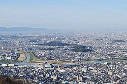
 Panoramic view of downtown Habikino and Furuichi tomb group heritage site | |
 Location of Habikino in Osaka Prefecture | |
| Coordinates: 34°33′N 135°36′E / 34.550°N 135.600°E | |
| Country | Japan |
| Region | Kansai |
| Prefecture | Osaka |
| Government | |
| • Mayor | Tsuguo Kitagawa |
| Area | |
• Total | 26.45 km2 (10.21 sq mi) |
| Population (January 31, 2022) | |
• Total | 109,479 |
| • Density | 4,100/km2 (11,000/sq mi) |
| Time zone | UTC+09:00 (JST) |
| City hall address | 4-1-1 Konda, Habikino-shi, Ōsaka-fu 583-8585 |
| Website | Official website |
| Symbols | |
| Flower | Peach |
| Tree | Mandarin Orange |

Habikino (羽曳野市, Habikino-shi) is a city located in Osaka Prefecture, Japan. As of 31 January 2022[update], the city had an estimated population of 109,479 in 50918 households and a population density of 4100 persons per km2.[1] The total area of the city is 26.45 square kilometres (10.21 sq mi). The city is known for its grapes, and also for its large number of ancient kofun burial mounds. The city is also sometimes referred to by its former name Minami-Osaka (南大阪).
Geography
[edit]Habikino is located in the southeastern part of Osaka Prefecture, in the Kawachi Plain surrounded by Ikoma, Kongō, and Katsuragi Mountains and Mount Nijō. It is within about 20 kilometers from the center of Osaka metropolis.
Neighboring municipalities
[edit]Nara Prefecture
Osaka Prefecture
Climate
[edit]Habikino has a Humid subtropical climate (Köppen Cfa) characterized by warm summers and cool winters with light to no snowfall. The average annual temperature in Habikino is 14.2 °C. The average annual rainfall is 1475 mm with September as the wettest month. The temperatures are highest on average in August, at around 26.3 °C, and lowest in January, at around 2.7 °C.[2]
Demographics
[edit]Per Japanese census data,[3] the population of Habikino increased rapidly from the 1960s through 1990s, and has leveled off since.
| Year | Pop. | ±% |
|---|---|---|
| 1960 | 36,982 | — |
| 1970 | 77,134 | +108.6% |
| 1980 | 103,181 | +33.8% |
| 1990 | 115,049 | +11.5% |
| 2000 | 119,264 | +3.7% |
| 2010 | 117,702 | −1.3% |
History
[edit]The area of the modern city of Habikino was within ancient Kawachi Province and is located on the route of the Take-no-uchi Kaidō, a highway which connected the ancient capitals of Asuka and Heijō-kyō with the coast. Numerous kofun burial mounds were built in the area during the Kofun period, including many attributed to early Emperors. During the Heian period, the area was controlled by the Kawachi Genji clan, the ancestors of the Minamoto clan who dominated Japan during the Kamakura period.
After the Meiji restoration, the area became part of Osaka Prefecture from 1881. The villages of Furuichi, Imagatani, and Nishiura were created with the establishment of the modern municipalities system on April 1, 1889. On April 1, 1896 the area became part of Minamikawachi District, Osaka. Furuichi was elevated to town status on October 1, 1916. On September 30, 1956, Furuichi merged with the town of Takawashi and the villages of Nanyu, Nishiura, Imagatani, and Tanpi to form the town of Minami-Osaka (南大阪町). On April 1, 1957, Minami-Osaka annexed the neighboring village of Mihara. On January 15, 1959, Minami-Osaka was elevated to city status, and took the name of Habikino.
Government
[edit]Habikino has a mayor-council form of government with a directly elected mayor and a unicameral city council of 18 members. Habikino contributes one member to the Osaka Prefectural Assembly. In terms of national politics, the city is part of Osaka 14th district of the lower house of the Diet of Japan.
Economy
[edit]Habikino is a regional commercial center. It was traditionally known for grapes and figs. There is some light manufacturing, but agriculture remains central to the local economy.
Education
[edit]Universities and technical schools
[edit]- Osaka Prefecture University Habikino Campus (formerly Osaka Prefecture College of Nursing)
- Shitennōji International Buddhist University
Primary and secondary education
[edit]Habikino has 13 public elementary schools, five public middle schools and one combined elementary/middle school operated by the city government and one public high school operated by the Osaka Prefectural Department of Education.
Transportation
[edit]Railway
[edit]![]() Kintetsu Railway -
Kintetsu Railway - ![]() Kintetsu Minami Osaka Line
Kintetsu Minami Osaka Line
- (to Osaka Abenobashi) - Eganoshō - Takawashi - < Fujiidera - Hajinosato - Dōmyōji> Furuichi - Komagatani - Kaminotaishi - (to Kintetsu Gose, Kashiharajingū-mae, Yoshino)
Highway
[edit] Minami-Hanna Road (Habikino Interchange, Habikino-Higashi Interchange)
 National Route 166
 National Route 170 (Osaka Outer Loop Highway)
Bus
[edit]- Kintetsu Bus
- From Furuichi Station in the east, buses carry passengers on routes to Habikigaoka, Shitennōji International Buddhist University, Momoyama-dai, and Fujiidera Station.
- From Eganoshō Station in the west, there is a bus route to Kawachi-Matsubara Station which also covers Mihara-ku in Sakai.
- Kongō Bus
- Buses pick up passengers at Kaminotaishi Station.
Local attractions
[edit]- Furuichi Kofun Cluster, a group of Kofun.[4] They are recorded as World Heritage Sites.
- Honda Shiratori Haniwa Production Site, National Historic Site
- Kannonzuka Kofun, National Historic Site
- Tsūhō-ji ruins, National Historic Site
- Yachū-ji temple ruins, National Historic Site
Sister cities
[edit]Within Japan
[edit]International
[edit]Notable people from Habikino
[edit]- Makate Asai, writer
- Yu Darvish, baseball player
- Hiroki Uchi, idol singer, songwriter, actor and model
- Sayuri Uenishi, politician
References
[edit]- ^ "Habikino city official statistics" (in Japanese). Japan.
- ^ Habikino climate data
- ^ Habikino population statistics
- ^ "World Heritage Mozu-Furuichi Kofun Group: Mounded Tombs of Ancient Japan". www.mozu-furuichi.jp. Retrieved 2020-04-27.
External links
[edit]- Habikino City official website (in Japanese)


